To Understand the World We Need an Accurate Image of It
A World to Win's mission is to educate how maps govern the way we perceive the world. We strive to excite with carto-graphy as a medium to assert agency of representation by replacing outdated maps with those that bear equitable representation of regions and peoples.
Why are current map projections broken?
Maps are hugely important tools in our daily lives that influence our perception of the world. This perception is until today shaped by maps that have been created and used as tools for colonial endeavors and Western hegemonic claims. It is time to advance the representation of the world as it truly is - by equal area projection.
Mercator Projection
The 16th century Mercator Map came to shape how we see the world, but today, it has fallen in disrepute for multiple reasons:
Distortion of forms, shapes and sizes
Northward bias and eurocentrism
Colonial history
Gall-Peters Projection
The advancement of the Gall-formula by Arno Peters presaged a new era in map making. The maps are characterized by:
Proportionally-accurate depiction
Reversed orientation, or South-up maps
“The equal status of all peoples.” (Peters)
HoBo-Dyer Projection
The HoBo-Dyer map is widely considered the best compromise in comparable projections because of:
Following the legacy of Arno Peters
No distortion at 37.5° latitude
Greater compression near the poles
Our mission is to
Create critical maps to overcome bias and to challenge arbitrary power structures
Educate and challenge unconscious and skewed spatial conventions
Create maps to overcome cartographic fallacy, geographic illiteracy and alienation
Create a forum for critical cartography
Advance democracy through better understanding of dialectical processes between spatial relationships
Advance the struggle for human rights by viewing and representing people within the world equally
Develop new social awareness by expanding perception of the physical world we inhabit
See the world anew!
What is a HoBo-Dyer Projection map?
It is an equal area projection map, which implies that a region of interest in a particular portion of a map shares the same proportion of area as in any other part of the map. Since there are no cylindrical projections without distortions, mapmakers have had to make compromises. This particular projection has “zero distortion” of the standard parallels at 37.5 degrees latitude north and south. HoBo-Dyer maps thus offer an equitable representation of regions and peoples. It's widely considered the best compromise in comparable projections that can be achieved on a rectangular sheet of paper.

What’s up with the north-up orientation on maps?
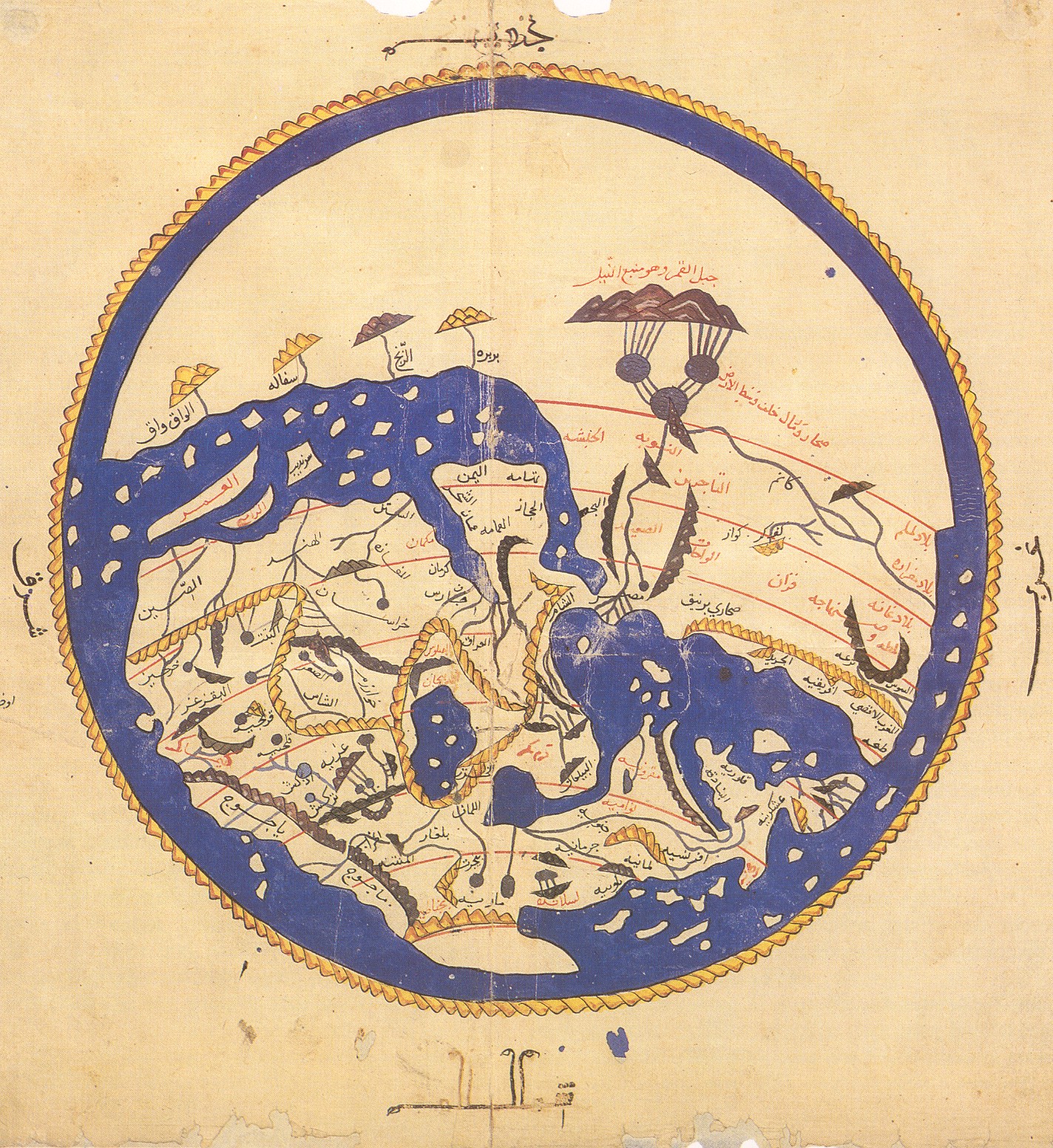
Astronomy tells us, there really is no ‘up’ or ‘down’ in space. There is no valid scientific reason why the Northern Hemisphere is “on top” on any map. North up orientations are arbitrary and have contributed to a culturally-laden bias through constructs such as “North”, “Europe”, “West” (is good) and “East”, “Asia”, “South”, and “Africa”, (is bad), or culturally inferior. In the Middle-Ages, the East was often displayed at the “top”. The origin of the term “the Orient”, and “orientation” can be traced back to this reference of East Asia as being at the top of a map. The convention of displaying the North as “up” might be explained by the fixed reference point of the North Star for navigational purposes. During the so-called age of exploration, European map-makers went back to follow the North-up convention for navigational reference. The South-up (or upside down maps or reversed maps) is an orientation with the South at the “top”, representing a complete 180° rotation. The South up orientation in maps was regarded as the correct direction for prayer with South as the focal point, because many of the communities that first converted to Islam in the seventh and eighth centuries lived directly north of Mecca. Most early Islamic world maps were oriented this way, with the South at the top. By flipping the spherical body of earth upside down on a flat piece of paper, we can see the physical world through entirely new perspective: Northern Europe, Canada and Russia lose predominance, and the significance of the Southern Hemisphere is considerably enhanced. Reversed maps offer the viewer a viscerally upending experience – as though seeing the world for the first time. Photo: Al-Idrisi world map, 12th century.
How Map Depictions Evolved from the Imaginative to the Precise
In the pre-global era of map-making, maps were, generally speaking, localized geographic depictions, as they were not informed by the geographies of the rest of the globe. Maps of this era were not characterized for being accurate geographically; they were a medium to tell stories about the immediate habitat, the fauna and flora, as well as depicting relationships of objects to each other, as maps do, for hunting purposes for instance. In the proto-global era of map-making during the so-called “Age of Exploration” from the 15th to the 18th century, cartography took a decisive turn to serve the interests of the covetous rulers of Empire; it produced the maps that would charter the despoilment and pillaging that is synonymous of imperial colonialism. The era of maritime exploration ushered in a race for overseas economic enterprise which led to the rise of the militarization of the oceans for the bourne of extra-territorial land conquest. European colonizers explored, savagely usurped, and extra-territorially and illegitimately claimed the land of the Indigenous populations that inhabited these lands. Native populations were enslaved, their natural resources were purloined.<br>The transition from the proto-globalist era to the modern-day globalist era was accelerated by technological advances and via international trade and exchange of goods, services, ideas, culture, beliefs, communication, and capital. Photo: 16th century depiction of a Ptolemy world map
